The Pechora River is the largest river of the Russian North

Pechora (Komi Pechӧra, Nen. Sanero'' yakha) is a river in the Komi Republic and the Nenets Autonomous Okrug of Russia.
Content
- Characteristics of the Pechora River
- Source of the Pechora River
- Where is the Pechora River located?
- Mouth of the Pechora River
- Where does the Pechora River flow?
- Tributaries of the Pechora River
- Hydrology of the Pechora River
- Settlements on the banks of the Pechora River
- Economic use of the Pechora River
- Ecology of the Pechora River
- Access roads to the Pechora River
- Relief and soils of the Pechora River
- Vegetation of the Pechora River basin
- What kind of fish is found in the Pechora River
- Sights of the Pechora River
Characteristics of the Pechora River
Source of the Pechora River
The length of the Pechora River is 1809 km, the area of the Pechora River basin is 322 thousand km². The Pechora River is the largest river in the European North of Russia. Where does the Pechora River begin? This is interesting, the source of the Pechora River originates in the Northern Urals, starting with three sources on the western side of the Ural Range in the southeastern part of the Komi Republic, and flows initially mainly to the southwest. The height of the source of the Pechora River is 630 m above sea level.

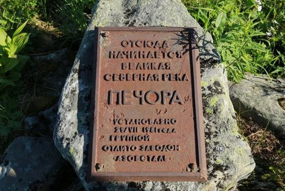
The source of the Pechora River is located practically on the border of Asia and Europe, and it is at this source that a commemorative cast-iron plate was installed, indicating where the Pechora River originates.
Where is the Pechora River located?
The Pechora River flows through the Komi Republic, Perm Territory, Vologda and Arkhangelsk regions.
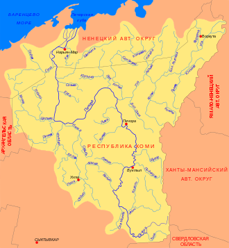
From the source to the mouth of the Unya River, Pechora has a mountainous character. At the village of Yakshi (after the confluence of the Volostnitsa River) it turns north and flows along the Pechora Lowland to Ust-Usa. After the mouth of the river, Usy turns west, forming a wide bend with two large bends. The width of the channel here reaches 2 km; extensive floodplain meadows appear in the valley. In the area of Ust-Tsilma (after the confluence of the Pizhma and Tsilma rivers), the Pechora again turns north, in this section its wide floodplain is cut by numerous channels (“balls”) and oxbow lakes.
Mouth of the Pechora River
Approximately 130 km from the mouth, the Pechora is divided into two branches - eastern (Bolshaya Pechora) and western (Malaya Pechora). Below, in the Naryan-Mar region, the river forms a delta about 45 km wide.
Where does the Pechora River flow?
You can often hear the question - where does the Pechora River flow? Or which sea does the Pechora River flow into (which ocean does the Pechora River flow into)?
This is interesting because the Pechora River flows into the Pechora Bay of the Pechora Sea. The Pechora Sea is in fact the water area of the Barents Sea, which belongs to the Arctic Ocean basin. So there will be several correct answers to the question of where the Pechora River flows.
The surge currents in the Pechora River extend south to the village of Oksina.
The Pechora basin is the largest water system of great economic importance in the region.
Tributaries of the Pechora River
The Pechora River has many large and small tributaries. The main tributaries of the Pechora River are Unya, Northern Mylva, Velyu, Lemyu, Kozhva, Lyzha, Izhma, Neritsa, Pizhma, Tsilma, Sula, Borovaya (left); Ilych, Podcherye, Podcherem, Shchugor, Usa, Laya, Yorsa, Sozva, Shapkina, Kuya (right).
Hydrology of the Pechora River
The Pechora River has a mixed diet, with a predominance of snow. The flood begins in late April - early May, maximum - in mid-May in the middle reaches and lower reaches until the first days of June. In summer and winter there is low water. Summer low water - from mid-July to August, often interrupted by rain floods. The average annual water flow is 4100 m³/s at the mouth. Freezes at the end of October; The opening of the Pechora River occurs from the upper reaches and is accompanied by ice jams.
Settlements on the banks of the Pechora River

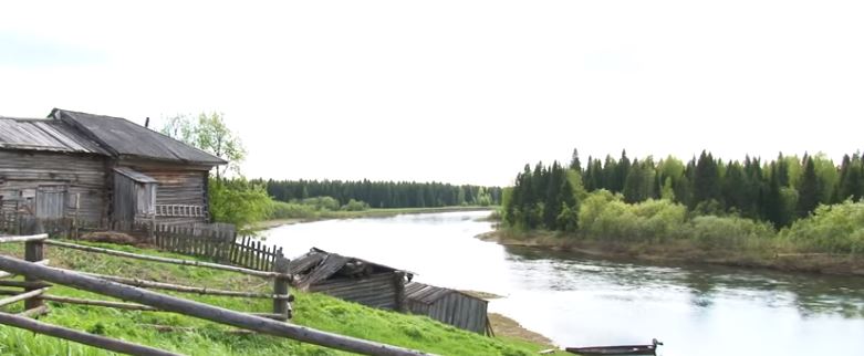
There are many small villages on the banks of the Pechora River. The most important piers on the Pechora River are Naryan-Mar, Ust-Tsilma, Pechora, Vuktyl
Other settlements on Pechora are Komsomolsk-on-Pechora, Troitsko-Pechorsk, Akis, Ust-Unya, Aranets, Brykalansk, Peschanka, Sokolovo, Ulyashovo, Rodionovo, Ust-Usa, Shchelyabozh, Zakharvan, Denisovka, Mutny Continent, Kipievo.
Economic use of the Pechora River
Regular navigation on the Pechora River is possible to Troitsko-Pechorsk, in spring and autumn - to Ust-Unya - 1541 km. Sea vessels rise upstream to the seaport of Naryan-Mar (110 km from the mouth). Marinas are available in the following settlements: Novy Bor, Ust-Tsilma, Akis, Pechora, Vuktyl.
Fishing is developed in the Pechora River (salmon, whitefish, vendace).
In the Pechora basin there are deposits of coal, oil and gas, gold, manganese, quartz and its varieties, and titanium.
Ecology of the Pechora River
The main sources of pollution in the river basin. Pechora are enterprises of the energy, oil refining, coal mining, gas mining, logging and woodworking industries [3]. Emergencies associated with oil production and transportation pose a particular danger. Due to the density of the hydrographic network, oil pipelines often cross watercourses, so during oil spills the concentration of oil products in surface waters ah region can reach 200-300 mg/dm3.
Technogenic flows entering the natural environment during the extraction of oil and gas condensates are multicomponent and contain pollutants that are geochemically active, very mobile, often highly toxic (among them there are many substances of the 1st and 2nd hazard classes) and therefore dangerous for the natural environment. environment, especially biota.
The severity of possible negative environmental consequences when the natural environment is polluted with oil and petroleum products is determined not only by the levels of the actual emergency input of pollutants, but also by the characteristics of their behavior in soils and, above all, by the activity of secondary intrasoil migration.
To date, as a result of emergency situations, the ecosystems of the Pechora basin have been exposed to technogenic impacts. In addition, river ecosystems in the river basin. Pechory continues to experience multifactorial pollution associated with the release of heavy metal compounds, petroleum products, flotation reagents, organic substances and household wastewater into the aquatic environment. It is important to emphasize that the anthropogenic impact on ecosystems is carried out under conditions of a harsh climate, widespread permafrost, low self-purification potential and the weak ability of aquatic ecosystems for self-regulation with low species diversity of biocenoses.
The deterioration in the quality of river waters has negatively affected the general condition of the ichthyofauna of Pechora and, above all, whitefish, which are a kind of biological indicator of anthropogenic changes in the habitat.
Pechora carries its waters through the delta to Pechora Bay, which has unique fish stocks. The main commercial species here are salmon and whitefish. The current state of the Pechora whitefish populations is alarming, since the total commercial stock has decreased threefold. According to a number of authors, the loss of fish-producing properties of the river is quite possible. Pechora and the destruction of the gene pool of the basin due to excessive technogenic impacts on the ecosystem.
Access roads to the Pechora River
Almost along the entire length of the Pechora River from the mouth to the village of Ust-Unya, located at the mouth of the Unya tributary, settlements located along the coastline are connected by a network of roads. Above the village of Ust-Unya the road network is not developed.
The village of Troitsko-Pechorsk is connected by railway with Sosnogorsk and Ukhta. The railway line also passes through the city of Pechora.
There are airfields in the following settlements: Naryan-Mar, Novy Bor, Ust-Tsilma, Pechora, Ust-Voya, Ust-Soplesk, Podcherye, Vuktyl, Ust-Ilych.
Relief and soils of the Pechora River
In the upper reaches of the Pechora River

The relief in the area of the source is mountainous, there are rock outcrops. There are many rapids and rifts. The river drop in this area is 3 ‰. The shores are steep, rocky, and in some places they look like a narrow canyon.
In the interfluve of the Pechora River and its right tributary, the Bolshoi Shezhim River, there is a karst area. There are many caves, grottoes and failures, washed by water in layers of limestone. In the area of Shezhim is the Shezhimskaya Cave. Many streams and even rivers (for example, Maly Shezhim) disappear underground, where they continue to move.
On the right bank of the Pechora, 16 km above the mouth of Bolshoi Shezhima, there is the Jordansky Log, and the Medvezhya, Ledyanaya and Tufovaya caves. In the area of Ust-Unya is the place where the Unya River flows into Pechora, the rocks recede.
In the area from the mouth of the Ilych tributary to Troitsko-Pechorsk, the right bank of the river is mountainous, and the left bank is low and littered with ridges of stones and boulders.
In the area of Troitsko-Pechorsk, the Pechora flows in the original banks. Below, for 100 km, the banks are low.
In the area below the village of Vuktyl, the banks of the Pechora are high, indigenous, reaching 15-45 m, in places coming close to the water.
In the area of the confluence of the Shchugor, the coast is 75-100 m high, composed of marl slabs. The shore is rocky and pebbly. Up to Ust-Voi, along the cliffs in the scree of the high banks of the Pechora, there are outcrops of gray and greenish-gray dolomites, and below Soplex - grindstone. They began mining and cutting grindstone on Brusyanotochilinnaya Mountain, located near the mouth of the Soplex, more than 300 years ago, in the 17th century.
Below Ust-Voi, high and steep banks are replaced by flatter and lower ones. Despite the fact that the number of shoals, spits and riffles in the Pechora channel below Ust-Voi does not decrease, the rocks composing them are gradually changing. Pebble and gravel-rocky spits are becoming less and less common, and completely sandy banks are becoming more common and becoming wider. In general, the soils remain heavy, so the river bed is resistant to erosion.
In the section from Ust-Usa to Ust-Tsilma, the left bank is high. A rocky clay bank juts deep into the channel. After several tens of kilometers, the right bank begins to gradually rise. Clay slopes overgrown with dark spruce trees are shaded in places by a strip of peat. At times, reddish sandstone stones are found in the gray clay of cliffs, for example, near the village of Shchelyayur. Frequent landslides occur everywhere and ravines. The river bed also becomes unstable.
Below the Izhma tributary, the right bank of the Pechora, covered with taiga, remains steep and high. Then it decreases, and in the area of the village of Ust-Tsilma, both banks of the river become low. Below Ust-Tsilma, along the low left bank of the river, a desert sandbank stretches for five kilometers - sands not fixed by vegetation.
Below the village of Khabarikha, the right bank of the Pechora rises, becomes high and steep. The outcrops here are heavy moraine clay of gray or brown color, with layers of yellow sand and sometimes peat. Only near the mouth of the Sula River are there rock outcrops. The ravines, running one after another, divide the coast into separate pyramids.
In the lower reaches the river bed is unstable, the soils are light and sandy. The movement and redistribution of runoff along small and large channels (locally called “balls”) causes landslides and bank erosion into the interior of the continent for tens and even hundreds of meters. For several years, Pechora has been intensively eroding the right bank, on which the village of Khabarikha stands. Over the past 50 years, due to erosion and landslides of the banks of Nizhnyaya Pechora, people have been resettled from the villages of Lavrino, Klimovka, Rosvina, as well as from the city of Pustozersk, founded in 1499.
Vegetation of the Pechora River basin
Before the confluence of the Usa River, more than 80% of the territory of the Pechora watershed is occupied by forests, and swamps - about 10%. Further north, the tundra zone begins. Along its course, the Pechora River abruptly changes its flow direction several times, crossing the taiga, forest-tundra and tundra zones.
What kind of fish is found in the Pechora River
The Pechora River is home to 32 fish species belonging to 15 families, which form relatively stable populations. The following types of Pechora fish are valuable.
– semi-anadromous fish species in the Pechora River: pink salmon, salmon (Atlantic salmon), omul, vendace, Siberian whitefish, European smelt, nelma;
– native fish species of the Pechora River: Arctic char (residential form), broad whitefish, peled, Siberian grayling, European grayling.
The introduced species are pink salmon and sterlet. There is convincing evidence of the presence of Siberian sturgeon, verkhovka and river flounder in the Pechora River basin.
Other fish that live in Pechora include river lamprey, crucian carp, ide, dace (upper reaches of the river), roach, bream (found infrequently, in the middle reaches, in Izhma, Tsilma), minnow, lake minnow, river eel - occasionally found at the mouth of the river , pike, perch, ruff, sculpin, freshwater goby, burbot.
Sights of the Pechora River
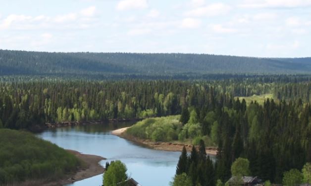
The Pechora flows in vast areas through untouched, sparsely populated territory. On the territory of the Pechora River drainage basin, a huge number of nature reserves and reserves have been created, and there is a national park. There are natural monuments participating in the competition for the title of one of the Seven Wonders of Russia. It is believed that in the upper reaches of the Pechora River there are the last forests in Europe untouched by man.
There are many hiking, skiing and water routes on the Pechora River. Extreme recreation on the Pechora River includes mountaineering, mountain trekking, caving, and rafting. On the Pechora River you can relax on the beach in places where there are no high ravines and swamps. Such places exist in the lower part of the Troitsko-Pechorsky, Pechora and Izhemsky districts, as well as on the coastal sections of the Vuktyl urban district. In these picturesque places there are many pebble-sand and just sandbanks. At the very beginning of August, there is no longer any midges and the water is relatively warm.
Eventful, ethnographic, equestrian and rural recreation on the Pechora River is common in the Troitsko-Pechora, Vuktyl, Pechera, Ust-Tsilma and Naryan-Mar regions. Ethnographic festivals of Mansi, Komi-Zyrian and Nenets culture are held on their territory. Rafting on the Pechora River has long been known and well tested by thousands of people. Pros raft in the upper reaches of Pechora. Water operators recruit commercial groups for rafting along part of the middle and almost the entire lower section of the Pechora River. From Ust-Tsilma to Naryan-Mar, the Pechora River consists of a labyrinth of channels that only sometimes come together. But the rafting organizers know the area well. The route along the tributaries is very winding, but you should stick to it so as not to run aground.