Currents of the Barents Sea

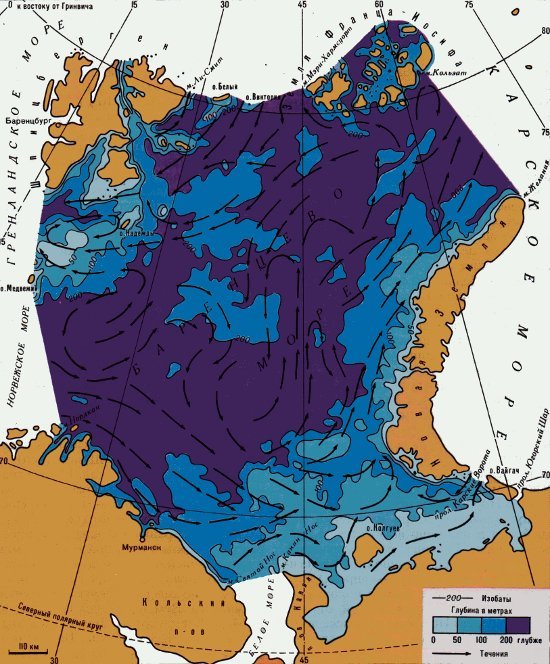
General scheme of currents in the Barents Sea
How sea currents are formed in the Barents Sea, what affects their direction and speed.
The general circulation of waters in the Barents Sea is formed under the influence of the influx of water from neighboring basins, bottom topography and other factors. As in neighboring seas of the northern hemisphere, the general movement of surface waters is counterclockwise.
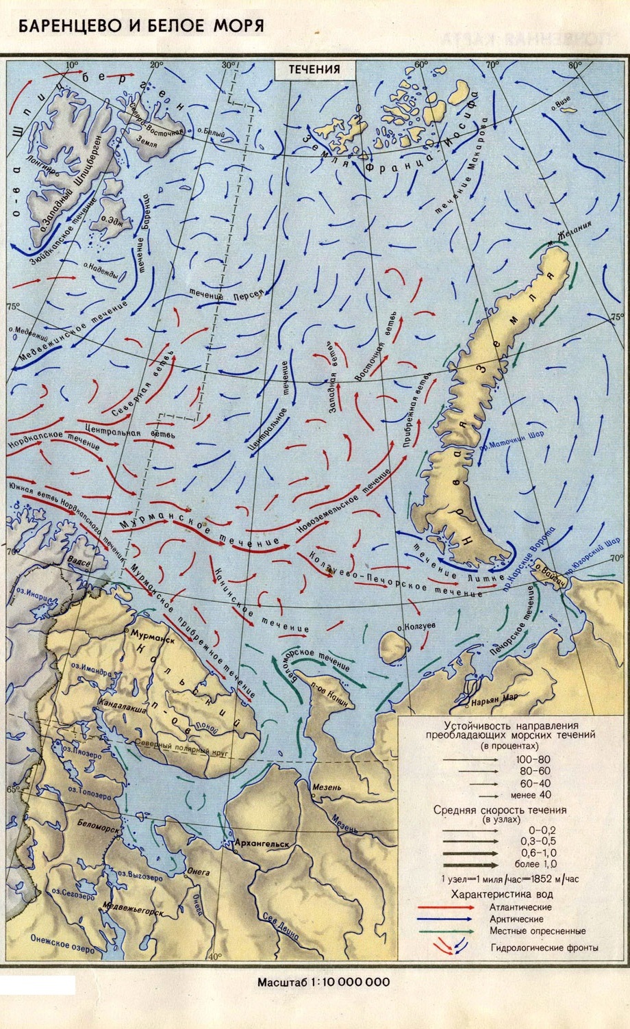
The most powerful and stable flow, which largely determines the hydrological conditions of the Barents Sea, forms the warm North Cape Current.
North Cape Current
The warm North Cape Current enters the Barents Sea from the southwest and moves east in the coastal zone at a speed of about 25 cm/s; further seaward its speed decreases to 5–10 cm/s. Approximately 25°E The warm North Cape Current is divided into the Coastal Murmansk and Murmansk Currents.
Coastal Murmansk Current
The coastal Murmansk Current, 40–50 km wide, spreads to the southeast along the coast of the Kola Peninsula, penetrates into the Throat of the White Sea, where it meets the outlet White Sea Current and moves east at a speed of 15–20 cm/s. The Kolguev Island divides the Coastal Murmansk Current into the Kanin Current, which goes to the south-eastern part of the sea and further to the Kara Gate and Yugorsky Shar straits, and the Kolguev Current, going first to the east and then to the north-east, to the coast of Novaya Zemlya.
Murmansk Current
The Murmansk Current, about 100 km wide, with a speed of about 5 cm/s, extends significantly more seaward than the Coastal Murmansk Current. Near the meridian 40°E, having encountered an increase in the bottom, it turns to the northeast and gives rise to the Western Novaya Zemlya Current, which, together with part of the Kolguev Current and the cold Litke Current entering through the Kara Gates, forms the eastern periphery of the cyclonic circulation common to the Barents Sea . In addition to the branched system of the warm North Cape Current, cold currents are clearly visible in the Barents Sea. Along the Perseus Upland, from northeast to southwest, along the Medvezhinsky shallow waters, the Perseus Current runs. Merging with the cold waters of the island. Hope, it forms the Medvezhinsky Current, the speed of which is approximately 50 cm/s.
Other currents in the Barents Sea
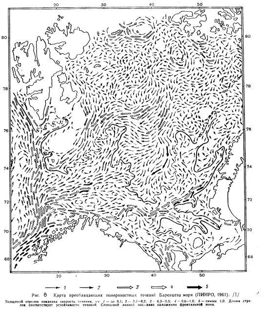
Currents in the Barents Sea are significantly influenced by large-scale pressure fields. Thus, when the Polar Anticyclone is localized off the coast of Alaska and Canada and with the Icelandic Low located relatively western, the West Novaya Zemlya Current penetrates far to the north, and part of its waters goes into the Kara Sea. Another part of this current deviates to the west and is strengthened by waters coming from the Arctic Basin (east of Franz Josef Land). The influx of surface Arctic waters brought by the East Spitsbergen Current is increasing.
With the significant development of the Siberian High and at the same time the more northern location of the Icelandic Low, the outflow of water from the Barents Sea through the straits between Novaya Zemlya and Franz Josef Land, as well as between Franz Josef Land and Spitsbergen, prevails.
The general picture of currents in the Barents Sea is complicated by local cyclonic and anticyclonic gyres.
Tides in the Barents Sea are caused mainly by the Atlantic tidal wave, which enters the sea from the southwest, between the North Cape and Spitsbergen, and moves east. Near the entrance to Matochkin Shar, it turns partly to the northwest, partly to the southeast.
The northern edges of the sea are influenced by another tidal wave coming from the Arctic Ocean. As a result, interference of the Atlantic and northern waves occurs off the northeastern coast of Spitsbergen and near Franz Josef Land. The tides of the Barents Sea almost everywhere have a regular semidiurnal character, as do the currents they cause, but the change in the directions of tidal currents occurs differently in different areas of the sea.
Along the Murmansk coast, in the Czech Bay, in the west of the Pechora Sea, tidal currents are close to reversible. In open parts of the sea, the direction of currents in most cases changes clockwise, and on some banks - counterclockwise. Changes in the directions of tidal currents occur simultaneously throughout the entire layer from the surface to the bottom.
The highest speed of tidal currents (about 150 cm/s) is observed in the surface layer. Tidal currents are characterized by high speeds along the Murmansk coast, at the entrance to the White Sea Funnel, in the Kanin-Kolguevsky region and in the South Spitsbergen shallow waters. In addition to strong currents, tides cause significant changes in the level of the Barents Sea. The height of the tide off the coast of the Kola Peninsula reaches 3 m. In the north and northeast, the magnitude of the tides becomes smaller and off the coast of Spitsbergen it is 1-2 m, and off the southern coast of Franz Josef Land it is only 40-50 cm. This is due to the peculiarities bottom topography, coastal configuration and interference of tidal waves coming from the Atlantic and Arctic oceans.
In addition to tidal fluctuations, seasonal level changes can also be observed in the Barents Sea, caused mainly by the influence of atmospheric pressure and winds. The difference between the maximum and minimum positions of the average level in Murmansk can reach 40-50 cm.
Strong and will continue Strong winds cause surge level fluctuations. They are most significant (up to 3 m) off the Kola coast and off Spitsbergen (about 1 m), smaller values (up to 0.5 m) are observed off the coast of Novaya Zemlya and in the southeastern part of the sea.
Large expanses of clear water, frequent and strong stable winds favor the development of waves in the Barents Sea. Particularly strong waves are observed in winter, when with long-lasting (at least 16-18 hours) western and south-western winds (up to 20-25 m/s) in the central regions of the sea, the most developed waves can reach a height of 10-11 m. In the coastal zone there are fewer waves. With prolonged northwestern storm winds, the wave height reaches 7-8 m. Starting in April, the intensity of the waves decreases. Waves with a height of 5 m or more are rare. The sea is calmest in the summer months; the frequency of storm waves with a height of 5-6 m does not exceed 1-3%. In autumn, the intensity of waves increases and in November approaches winter levels.

Warm and cold currents of the Barents Sea

Large and small currents of the Barents Sea