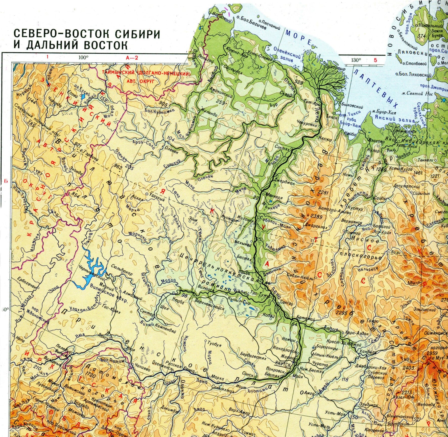
Map of the Lena River Basin
 Map of the Lena River Basin
The Lena is the largest river in Central Siberia, flowing into the Laptev Sea of the Arctic Ocean. The length including the delta is 4400 km. In some cases, a length of 4294 km is indicated, excluding the Bykovskaya channel (106 km) in the Lena delta. The basin area is 2490 thousand km². The annual flow is 515.6 km3.
The Lena River winds incredibly on the map of Russia. The Lena River flows through the territory of the Irkutsk region and Yakutia, some of its tributaries belong to the Transbaikal, Krasnoyarsk, Khabarovsk territories, Buryatia and the Amur region. The Lena River is the largest of the Russian rivers, whose basin lies entirely within the country. Also, the Lena River is the largest river in the world that flows entirely in the permafrost region.
The Lena River freezes in reverse order - from the lower reaches to the upper reaches.

Physical map of the Lena River basin
According to the nature of the flow, three sections are distinguished:
from the source to the mouth of Vitim;
from the mouth of Vitim to the mouth of Aldan;
from the mouth of the Aldan to the confluence of the Lena into the Laptev Sea.
Upper reaches of the Lena River
Source of the Lena River
Where is the source of the Lena River? The source of the Lena River is considered to be a small swamp 15 km from the Solntsepad pass and 10 km west of Baikal, the swamp is located at an altitude of 1470 m at the foot of the nameless peak of the Baikal ridge with a height of 2023 m. Thus, the height of the source of the Lena River is 1470 m above sea level . On August 19, 1997, a chapel was built at the source of the Lena River, where a memorial plaque was installed. The entire upper reaches of the Lena River before its confluence with Vitim, that is, almost a third of its length, is located in the mountainous Baikal region. Water consumption in the Kirensk area is 1100 cubic meters. m/sec.
Middle reaches of the Lena River
The middle flow includes the section of the Lena River between the mouths of the Vitim and Aldana rivers, 1415 km long. Near the confluence of the Vitim, the Lena enters Yakutia and flows along it to the very mouth. Having accepted Vitim, Lena turns into a very large, high-water river. Depths increase to 10-12 m, the channel expands, and numerous islands appear in it, the valley expands to 20-30 km. The valley is asymmetrical: the left slope is lower; the right one, represented by the northern edge of the Patom Highlands, is steeper and higher. On both slopes there are dense coniferous forests, only occasionally replaced by meadows.
From Olekma to Aldan, the Lena does not have a single significant tributary. Cutting through the Prilenskoye Plateau, the river flows for more than 500 km in a deep and narrow valley cut into limestone. Below the city of Pokrovsk, Lena opens onto a plain. As a result, a sharp expansion of the valley occurs, the flow speed slows down greatly - it nowhere exceeds 1.3 m/s, and for the most part drops to 0.5-0.7 m/s. The floodplain alone has a width of 5-7, and in some places 15 km, and the entire valley has a width of 20 or more kilometers.
Lower reaches of the Lena River
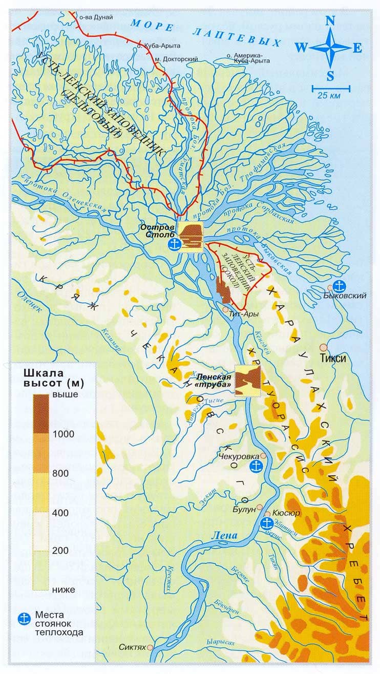
Below Yakutsk, the Lena River receives two main tributaries - Aldan and Vilyui. Now it is a gigantic stream of water; even where it runs in one channel, its width reaches 3 km, and its depth exceeds 16-20 m. Where there are many islands, the Lena overflows for 20-30 km. The banks of the river are harsh and deserted. Settlements are very rare. See the mouth of the Lena River on the map.
In the lower reaches of the Lena, its basin is very narrow: from the east, the spurs of the Verkhoyansk Range, the watershed of the Lena and Yana rivers, approach; from the west, insignificant elevations of the Central Siberian Plateau separate the basins of the Lena and the Olenyok River. Below the village of Bulun, the river is compressed by the Kharaulakhsky ridge coming very close to it from the east and the Chekanovsky ridge from the west. About 150 km from the sea, the vast Lena delta begins.

Mouth of the Lena River on the map
The Lena River to this day remains the main transport artery of Yakutia, connecting its regions with the federal transport infrastructure. The main part of the “northern delivery” is carried out along the Lena River. The Kachug pier is considered the beginning of navigation, however, upstream from the port of Osetrovo, only small ships pass through it. Below the city of Ust-Kut, right up to the confluence of the Vitim tributary on the Lena, there are still many difficult areas for navigation and relatively shallow places, forcing annual dredging work
The navigation period lasts from 120 days in the lower reaches to 180 days in the upper reaches.
Main ports on the Lena (from source to mouth):
Osetrovo (3500 km from the mouth of the Lena; 3620 km from Cape Bykov, Ust-Kut) is the largest river port in Russia and the only one in the Lena basin connected to the railway, for which it is called the “gateway to the north”;
Kirensk (3319 km from Cape Bykov);
Lensk (2648 km; 2665 km from Cape Bykov) is the largest cargo port on the left bank, an important transport hub (in the Lensk area a “winter road” passes through the Lena), including serving the diamond mining industry of Mirny, for which it received the name “gate of the diamond region” ";
Olekminsk (2258 km from Cape Bykov);
Pokrovsk (1729 km from Cape Bykov);
Yakutsk (1530 km; 1638 km from Cape Bykov) - plays a major role in the transshipment of goods arriving from the port of Osetrovo (Ust-Kut, Lena railway station);
Sangar (1314 km from Cape Bykov)
Tiksi (0 km; seaport of the Laptev Sea).
Kilometers of settlements and others objects is carried out from Cape Bykov 72°00′00″ N. w. 129°07′01″ E. d.HGYAO.
Passenger high-speed shipping
Between Ust-Kut and Yakutsk there are high-speed lines at the Polesie, Meteor, and Raketa SECs. High-speed line operator - Lenaturflot-S company
Ust-Kut — Kirensk
Kirensk — Vitim
Vitim - Peleduy - Lensk
Lensk — Olekminsk
Yakutsk — Olekminsk
From Yakutsk to the north
As of 2017, SPK Meteor and the last 2 operating SPK Raketa operate in the port of Yakutsk.
Passenger shipping on displacement vessels
On the Lena, until 2004, the last transport line in Russia on paddle steamers operated (the steamship Gogol in Arkhangelsk operated later, but this is a tourist line). In 2017, one ship is stationed in Kirensk, the second in Yakutsk. As of 2017, the transport line Yakutsk - Tiksi operates on the motor ship of project 646 Mechanic Kulibin, operator - Lenaturflot. Some suburban lines operate on OM and Moscow ships of different operators. On the route Yakutsk - Nizhny Bestyakh there is active traffic of car ferries and hovercraft Khivus.
The largest ports of the Lena tributaries: Bodaibo at 292 km from the mouth (Vitim River), Khandyga at 456 km, Dzhebariki-Khaya at 511 km from the mouth (Aldan River).
Cruise shipping
Since the late 1980s, 2 cruise ships of project Q-065 have been operating on the Lena. They run along the lines Yakutsk - Lena Pillars, Yakutsk - Tiksi, Yakutsk - Lena Shcheki. In 2017, the motor ship Demyan Bedny rose above Kirensk for the first time and reached the village of Krasnoyarovo. In 1998-2013, the motor ship Mikhail Svetlov was owned by ALROSA Hotels CJSC, and Demyan Bedny was owned by Lenaturflot, and there was some competition between the two ships. In 2013, Mikhail Svetlov was sold to Lenaturflot, and now this company is an operator of cruises on the Lena.