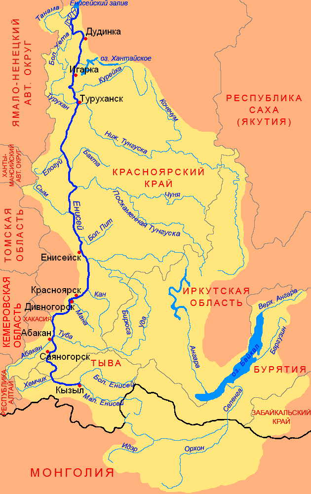
Map of the Yenisei River Basin

Map of the Yenisei River Basin
The Yenisei is one of the longest and deepest rivers in the world and Russia. It flows into the Kara Sea of the Arctic Ocean. The length is 3487 km, the basin area is 2,580,000 km² (the second largest in Russia), and the annual flow is 624.41 km3 (the deepest river in Russia).
The length of the Yenisei from the confluence of the Big Yenisei and the Small Yenisei is 3487 km (with the Small Yenisei - 4287 km, from the sources of the Big Yenisei - 4092 (4123) km). The length of the waterway: Ider - Selenga - Lake Baikal - Angara - Yenisei is 5550 km.
In terms of basin area (2,580 thousand km²), the Yenisei ranks 2nd among the rivers of Russia and Eurasia (after the Ob) and 7th among the rivers of the world. The Yenisei basin is characterized by sharp asymmetry: its right-bank part is 5.6 times larger than the left bank.
The Yenisei is a natural border between Western and Eastern Siberia. The left bank of the Yenisei ends the great West Siberian Plain, and the right bank represents the kingdom of mountain taiga. From the Sayan Mountains to the Arctic Ocean, the Yenisei passes through all the climatic zones of Siberia. Camels live in its upper reaches, and polar bears live in its lower reaches.

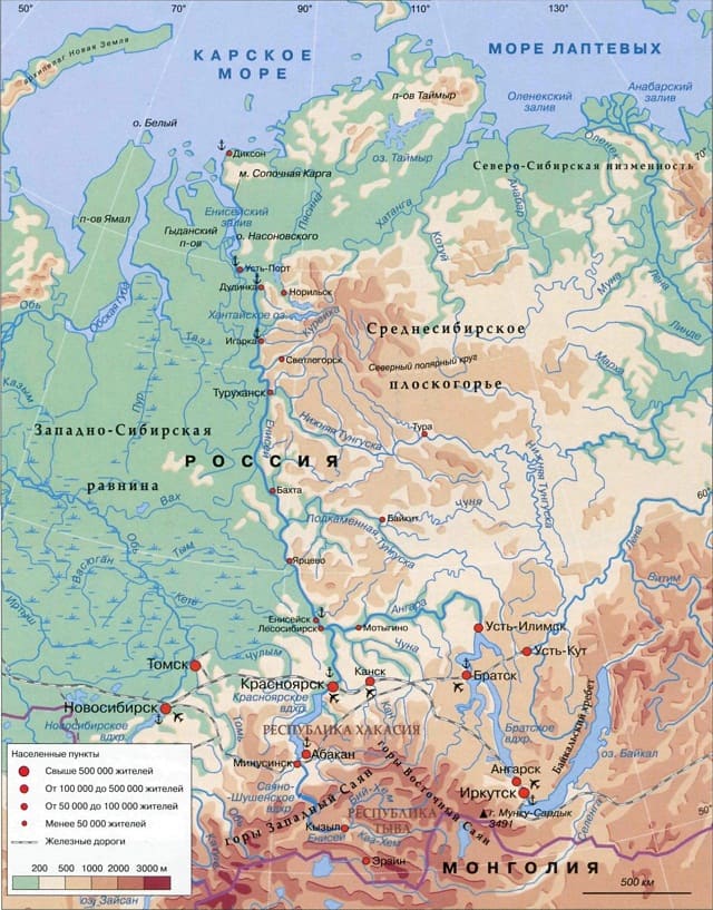
Physical map of the Yenisei River basin
The Yenisei itself begins from the city of Kyzyl, where the Big Yenisei and the Small Yenisei merge. The height of the source is 619.5 m above sea level. Over the first 188 km, the Yenisei flows under the name Upper Yenisei (Ulug-Khem), within the northern side of the Tuva Basin in the west, the river breaks into branches, the channel is replete with rifts, the width ranges from 100 to 650 m; the depth on the reaches is 4-12 m, on the rifts no more than 1 m. From Shagonar, the Sayano-Shushenskoye reservoir begins, formed by the dam of the Sayano-Shushenskoye hydroelectric station. Having accepted the Khemchik River on the left, the Yenisei turns north and for 290 km breaks through the Western Sayan Mountains and the Minusinsk Basin. Below the dam of the Sayano-Shushenskaya hydroelectric power station, the small Mainskoye reservoir begins, ending with the Mainskaya hydroelectric power station.
After the confluence of the left tributary - the Abakan River - the Krasnoyarsk reservoir begins (length 360 km), formed by the dam of the Krasnoyarsk hydroelectric station, located near the city of Divnogorsk, at the intersection of the Yenisei spurs of the Eastern Sayan. The width of the valley here is 5 km, the channel is more than 500 m. Between Krasnoyarsk and the mouth of the Angara, the Yenisei valley expands again, the river loses its mountainous character, but there are still underwater ridges in the channel - a continuation of the spurs of the Yenisei Ridge. Below the confluence of the Angara, the character of the valley and bed of the Yenisei changes dramatically. The right bank remains mountainous, the left bank becomes low and floodplain. The width of the Yenisei valley at the mouth of the Lower Tunguska is about 40 km, at Dudinka and Ust-Port up to 150 km, the channel is 2.5-5 km; the minimum depths of the entire lower Yenisei range from 5 to 8.5 m. Below Dudinka, the prevailing depths are 20-25 m, the channel is divided into branches, the islands reach a length of 20 km. From the mouth of the Kureyka River, where tidal fluctuations in level are already felt, the mouth section of the Yenisei begins. The site of Cape Sopochnaya Karga is taken as the mouth section. Below the village of Ust-Port the Yenisei delta itself begins. The Brekhov Islands divide the channel of the Yenisei into many channels, of which four main branches stand out: the Okhotsk Yenisei, the Kamenny Yenisei, the Big Yenisei and the Small Yenisei; the total width of the channel here is 50 km. Below, the Yenisei flows in one channel, in the “throat”, forming the Yenisei Bay of the Kara Sea.
The Yenisei belongs to the type of rivers of mixed feeding with a predominance of snow. The share of the latter is slightly less than 50%, rain - 36-38%, underground in the upper reaches up to 16%, and decreases towards the lower reaches. Freezing of the Yenisei begins in the lower reaches (beginning of October). The Yenisei is characterized by intensive formation of inland ice and autumn ice drift. Freeze-up occurs in the lower reaches from the end of October, in mid-November in the middle reaches and near Krasnoyarsk, and in late November - December in the mountainous part. In some areas, thick ice deposits appear in the riverbed. Most of the Yenisei is characterized by extended spring floods and summer floods; in winter there is a sharp reduction in flow (but levels drop slowly due to the development of floods). The upper reaches are characterized by extended spring-summer floods. The flood on the Yenisei begins in May, sometimes in April, on the middle Yenisei somewhat earlier than on the upper Yenisei, on the lower Yenisei in mid-May - early June. Spring ice drift is accompanied by congestion. The range of fluctuations in the Yenisei level in the upper reaches is 5-7 m in expansions and 15-16 m in contractions; in the lower reaches it is larger (28 m at Kureika), decreasing towards the mouth (11.7 m at Ust-Port).
The Yenisei is the most important waterway in the Krasnoyarsk Territory. Regular shipping - from Sayanogorsk to the mouth (3013 km). The main cargo flows go from Krasnoyarsk to Dudinka. Main ports and marinas: Abakan, Krasnoyarsk, Strelka, Maklakovo, Yeniseisk, Turukhansk, Igarka, Ust-Port. Sea vessels rise to Igarka. A unique ship lift was built to transport ships from the lower tail of the Krasnoyarsk hydroelectric power station to the upper. In the Republic of Tuva on the Yenisei there is local shipping (the main pier is Kyzyl).
Hydroelectric power stations (location downstream): Sayano-Shushenskaya Hydroelectric power station, Mainskaya hydroelectric power station, Krasnoyarsk hydroelectric power station.
Timber rafting is carried out along the Yenise