Hydrological regime of the Barents Sea
The hydrological regime of the Barents Sea is very diverse, which influences the hydrology.
The hydrological regime of the Barents Sea is very diverse and is formed as a result of the circulation of waters of different origins and with different properties:
- warm waters coming from the North Atlantic Ocean;
- warm waters of river origin;
- relatively cold local waters 4. cold polar waters.
In the previous section it was shown that thermohaline conditions in the Barents Sea are influenced by both heat advection by currents and radiation factors. Some elements of this influence determine the stability of climatic characteristics of temperature and salinity, while others (for example, non-stationary currents and ice conditions) form their spatial and temporal variability.
Let us consider the structure of temperature and salinity fields in their annual course, as well as the main processes that determine their distribution.
Barents Sea water temperature
In the Barents Sea, water temperature, to a much greater extent than in other Arctic seas, determines all processes associated with the density structure of water (convection, formation of a shock layer, etc.). In addition, in the Barents Sea, water temperature is the main indicator characterizing the distribution of warm Atlantic waters, which in turn determine the ice conditions and climate of the Atlantic sector of the Arctic.
The thermal regime of the Barents Sea is formed under the influence of a number of processes, the leading ones being autumn-winter convection, which equalizes the temperature from the surface to the bottom, and summer heating of the surface layer, which causes the appearance of a seasonal thermocline.
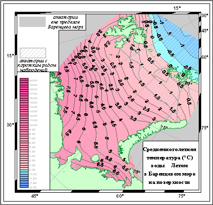
The large influx of warm Atlantic waters makes the Barents Sea one of the warmest in the Arctic Ocean. A significant part of the sea from the shores to 75°N latitude. It does not freeze all year round and has positive surface temperatures. The influence of heat advection of Atlantic waters is especially noticeable in the southwestern part of the sea and insignificant in the southeast due to the shallow depths in this area. However, it is precisely this circumstance that contributes to more intense radiation heating of this region in the summer and therefore in July-August the water temperature here it reaches 8°C.
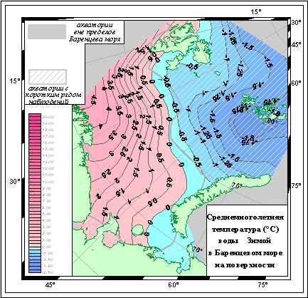
In the surface layer, the maximum temperature is observed in the southwestern part of the sea (9°C in June-September), the minimum (0°C) is at the ice edge. From July to October, the region of maximum temperatures also extends to the southeastern part of the sea, the position of the isotherms becomes close to the latitudinal one (Fig. 2).


Figure: Average long-term surface water temperature in summer and winter.
The seasonal change in water temperature in the Barents Sea is small everywhere; in the southwest and northern part of the sea it does not exceed 5-6°C and only in the southeast it reaches 10°C. In the Atlantic water mass in the extreme southwest of the sea, the surface water temperature in winter does not fall below 3°C and does not exceed 6°C; in summer it ranges from 7 to 13°C. In areas where ice is possible, the absolute minimum is limited to a freezing point of -1.8°C. Summer maximum temperatures in the surface layer reach 4-7°C in the northwestern part of the sea, 15°C in the southeast in the open part of the sea and 20-23 in Pechora Bay.
With depth, fluctuations in water temperature decrease. In the south-eastern part of the sea at a horizon of 50 m they are about 2/3 of their value on the surface.
The distribution of water temperature on the underlying horizons reflects the development of convection processes in the sea (in winter) and summer heating. In the summer, a seasonal thermocline is formed, which begins with the transition of the heat balance of the sea surface to positive values and continues until August-September, when the depth of the shock layer reaches such values at which mixing in the surface layer can no longer significantly affect the conditions in the thermocline layer . In most of the Barents Sea, the thickness of the quasi-homogeneous layer and the depth of the upper boundary of the thermocline by this time reach 30 m, and the greatest gradients occur in the layer of 30-50 m.
In the southwest of the sea, maximum water temperature gradients do not exceed 0.1°C/m, and in the rest of its deep-sea waters they reach 0.2°C/m; in the southeastern part of the sea and in coastal areas, the maximum gradients occur in the layer of 10-25 and 0-10 m and amount to 0.4°C/m
To a large extent, the distribution of temperature in the water column of the Barents Sea depends on the penetration of warm Atlantic waters, on winter cooling and on the bottom topography. Therefore, the vertical change in water temperature occurs unevenly.
In the southwestern part, which is most exposed to the influence of Atlantic waters, the temperature gradually and within small limits decreases with depth, remaining positive to the very bottom. In the northeast of the sea in winter, negative temperatures extend to a horizon of 100-200 m, deeper it rises to +1°C. In summer, the sea surface has a low temperature, which quickly drops to 25-50 m, where low temperature values (-1.5°C) achieved during winter cooling. Below, in the layer of 50-100 m, not affected by winter vertical circulation, the temperature is increased to -1°C. Thus, between 50 and 100 m there is a cold intermediate layer. In those depressions where warm waters do not penetrate and strong cooling occurs, for example, the Novaya Zemlya Trench, the Central Basin, etc., the water temperature is uniform throughout the entire thickness in winter, and in summer it drops from small positive values on the surface to -1.75 ° C at the bottom .
Underwater hills serve as obstacles to the movement of Atlantic waters, so the latter flows around them. In places where highs flow around, low temperatures rise close to the surface of the water. In addition, above hills and on their slopes, the water cools more. As a result, “cold water caps” characteristic of the Barents Sea banks are formed.
In the Central Highlands region, winter water temperatures are uniformly low from surface to bottom. In summer it decreases with depth and has minimal values in the 50-100 m layer. Below, the temperature rises again, but remains negative until the very bottom. Thus, here too there is an intermediate layer of cold water, but it is not underlain by warm Atlantic waters. In the southeastern part of the sea, temperature changes with depth have a pronounced seasonal pattern.
In winter, the temperature of the entire water column of the Barents Sea is negative. In spring, the upper 10-12-meter layer is warmed up; below it, the temperature drops sharply towards the bottom. In summer, the heating of the surface layer reaches its greatest values, so the temperature decrease between horizons of 10 and 25 m occurs sharply. In autumn, cooling equalizes the temperature throughout the entire layer, which by winter becomes almost uniform vertically.
Figure 4 shows vertical profiles of water temperature in four regions (western, northern, Novaya Zemlya and northeastern Fig. 3), characterizing the period of formation and destruction of the thermocline (May-November). It is clear from them that despite significant differences in the hydrological regime of the regions, they are characterized by a number of general patterns, in particular, a delay in the annual maximum water temperature as the depth increases and a slower drop in temperature in the fall compared to the rise in spring. In real conditions, these generalized water temperature distribution profiles are complicated by the existence of daily and synoptic thermoclines, uneven heat advection, internal waves, the influence of river runoff, and ice melting. For example, in the southeastern part of the sea in July, at a horizon of 10 and 20 m, a significant decrease in water temperature is observed, due to the fact that in June-July this area is characterized by a strongly pronounced density stratification, caused by the influx of a large volume of river water.
In summer, changes in the water temperature of the Barents Sea in layers different along the vertical gradient are practically unrelated. The exceptions are the wind mixing layer (0-10 m) and the seasonal thermocline layer (20-30 or 30-50 m), there is no connection between these layers.
Characteristic values of water temperature fluctuations caused by tidal variability are 0.2-0.5°C in homogeneous layers and up to 1.0-1.5°C in the thermocline layer.