Physical map of the Barents Sea and other maps of the Barents Sea
What do we know about the Barents Sea? Where is it located, what are its borders, what is the Barents Sea basin. You can learn about all this and much more from a selection of maps of the Barents Sea, which reflect its various aspects - depth, salinity, direction of currents and much more.
Where is the Barents Sea located?

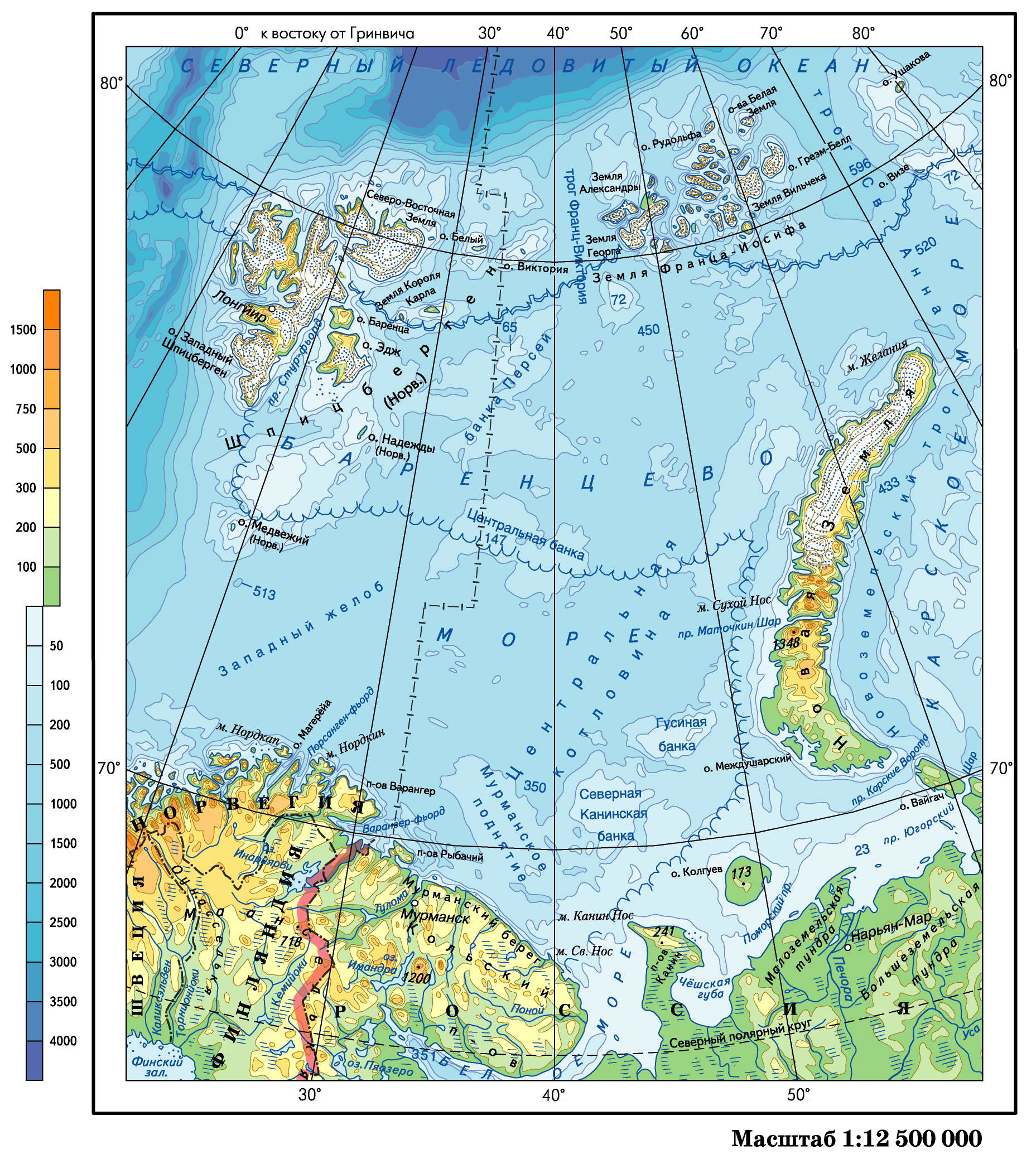
Physical map of the Barents Sea
Where is the Barents Sea on the world map? The Barents Sea is located on the northern European shelf, almost open to the Central Arctic Basin and open to the Norwegian and Greenland seas. The physical map of the Barents Sea shows that it belongs to the type of continental marginal seas. This is one of the largest seas in terms of area. Its area is 1424 thousand km2, its volume is 316 thousand km3, its average depth is 222 m, its greatest depth is 513 m.
Boundaries of the Barents Sea
The boundaries of the Barents Sea can be roughly drawn from the northern coast of Norway to the Spitsbergen archipelago, then to the Franz Josef Land archipelago, and then to Novaya Zemlya and again to the mainland coast.
What can a map of the Barents Sea tell you?
One glance at the map of the Barents Sea is enough to estimate the number of islands. Among the islands are the archipelagos of Spitsbergen and Franz Josef Land, Novaya Zemlya, the Islands of Hope, Kolguev and others. Small islands are mainly grouped into archipelagos located near the mainland or larger islands.
A map of the Barents Sea will show the complex dismemberment of the coastline, which forms numerous capes, fjords, bays, and bays. Certain sections of the Barents Sea coast belong to different morphological types of coasts. Similar shores are found on Franz Josef Land and on the island of North-East Land in the Spitsbergen archipelago.
A physical map of the Barents Sea can show the depths. The bottom of the Barents Sea is a complexly dissected underwater plain, slightly inclined to the west and northeast. The deepest areas, including the maximum depth, are located in the western part of the sea. The bottom topography, in general, is characterized by the alternation of large structural elements - underwater hills and trenches with different directions, as well as the existence of numerous small (3-5 m) irregularities at depths of less than 200 m and terrace-like ledges on the slopes. The difference in depths in the open part of the sea reaches 400 m. The rugged bottom topography significantly affects the hydrological conditions of the sea.
As can be seen from the map of the Barents Sea, its position in high latitudes beyond the Arctic Circle, direct connection with the Atlantic Ocean and the Central Arctic Basin determine the main features of the climate. In general, the climate of the sea is polar marine, characterized by long winters, short cold summers, small annual changes in air temperature, and high relative humidity. Arctic air dominates in the northern part of the sea, and air of temperate latitudes dominates in the south. At the border of these two main currents there passes an atmospheric Arctic front, directed, in general, from Iceland through Bear Island to the northern tip of Novaya Zemlya. Cyclones and anticyclones often form here, affecting the weather patterns in the Barents Sea.
- Barents Sea salinity map
- Temperature map of the Barents Sea
- Map of the depths and topography of the Barents Sea bottom
- Ice map of the Barents Sea
- Current map of the Barents Sea
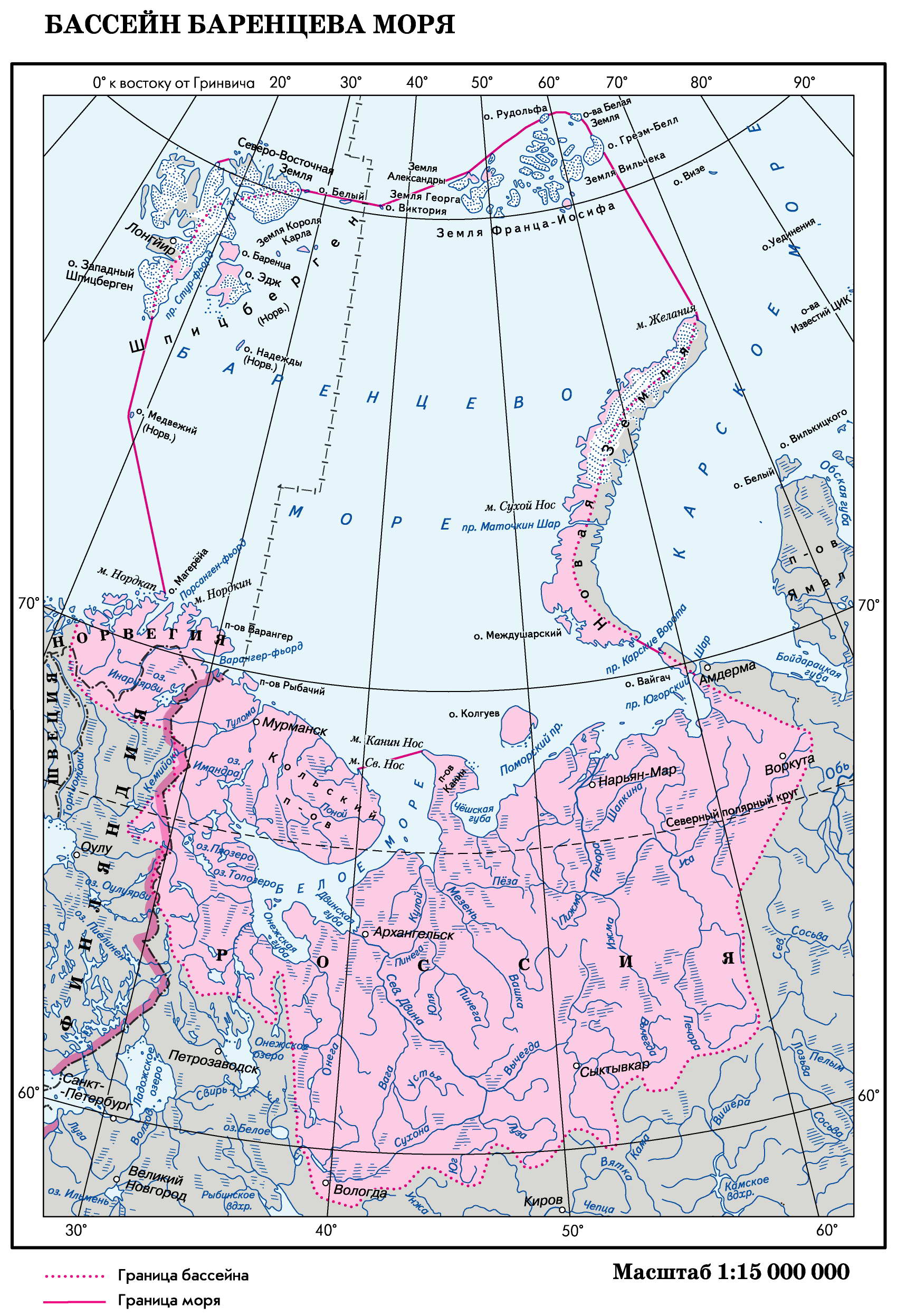
Barents Sea Basin
The Barents Sea basin occupies a large area, but the river flow in relation to the area and volume of the sea is small and averages 163 km3 per year. 90% of the river flow is concentrated in the southeastern part of the sea. The largest rivers of the Barents Sea basin carry their waters to this area. The Pechora River discharges about 130 km3 of water in an average year, which is approximately 70% of the total coastal runoff into the sea per year. Several small rivers also flow here. The northern coast of Norway and the coast of the Kola Peninsula account for only about 10% of the flow. Here small mountain rivers flow into the sea. The maximum continental runoff is observed in spring, the minimum in autumn and winter.

Map of the Barents Sea basin